First published on 09/05/2013, and last updated on 03/05/2018
By: Giovanni Reyes, Executive Secretary, KASAPI (Member)
“A 3-day trip, 13-hour travel, 3 vehicles, 3 drivers, 3 speakers for a 3-hour Planning Workshop” an untiring Dave de Vera, Executive Director of PAFID would say about the whole activity. It summarizes the kind of work often encountered for ICCAs– harsh but exciting. The objective of the field workshop was to conduct a community consultation with three different barangays (villages) of Balbalan municipality on how to document, map, and conduct resource inventory of ICCAs within their ancestral domain. The three baragays included Pantikian, Talalang and Balbalasang. Participants were provided with an overview of the ICCA concept and the step-by-step activities to document traditional practices, including their Lapat system (traditional governance). Results included the following: identification of community representatives (CPR) to conduct the ICCA documentation project; organization of CPRs’ training for the project implementation; updating of the 3D map for reference in community planning and action planning; identification of timeframes for completion of the action or activity required (including the person(s) responsible).
Results included the following:
Identification of community project representatives (CPR);
Organization for the training of the CPR for the project implementation;
Updating of the 3D map for reference in community planning and Action Planning;
Identification of timeframes for completion of the action or activity required (including the person(s) responsible).
The site is Balbalasang, municipality of Balbalan, province of Kalinga, located in the Cordillera region of Northern Luzon. It is a rugged tableland rising from the Cordillera Central Range sprawling in a descending Eastward direction and in massive mountain alluvial fashion. Accessible from Manila by national road from the provincial capital City of Tabuk in the east and the capital town of Bangued, province of Abra in the West, we took the Abra route – unfortunately.
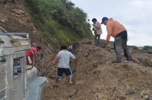
Indeed, it basically took us 2 days to reach Balbalasang from Bangued. We started from Bangued early on time, confident of reaching our field location the very same day. That was without counting with the recent heavy rains – which had made the roads extremely muddy and of course soon got our jeep stuck. After having hired an experienced local driver with a more powerful vehicle, we started again the next morning; and again we got stuck. Villagers around tried to help – in vain – and it finally took a bulldozer from the local Department of Public Works and Highways to free us. To make the experience complete, we were granted a
final stop 7km further, and had to transfer to a third vehicle. We finally reached Balbalasang in the afternoon; and everyone’s excitement at our arrival erased all sensation of fatigue. Not always easy to reach communities in The Philippines!
The community consultation started with a brief presentation on the ICCA concept, highlighting the different ICCAs in the country and how they manage to protect their ancestral lands and resources. Steps and procedures in documenting ICCAs were then presented. Fortunately, the community has already had a 3D map showing the extents of their ancestral lands. But since this was created in 2001, an updating is to be done. Apart from the 3D map, Balbalasang has an existing Ancestral Domain Management Plan, but with less emphasis on conservation, which is hence to be developed too.
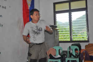
Mr. De Vera (PAFID) emphasized that ICCAs are nothing new since their existence is primarily based on traditional governance of indigenous communities. Used in the context of development and conservation, it is an additional layer of protection against extractive activities like mining. ICCAs are also recognized as significant contributors to Key Biodiversity Areas (KBAs), requiring other means of protection and conservation. Besides, ICCAs can also contribute to biomass and carbon sequestration, which can also be a form of defense against environmental plunder.
The meeting took note of the active existence of the Lapat System that forms the local community’s environmental management and protection practices. The different barangays wanted their Lapat system to be individually documented and treated separately. On the average, one Lapat is about 100 hectares. It was proposed and agreed that village leaders will meet to re-affirm traditional boundaries before the conduct of documentation of indigenous knowledge systems and practices. In addition to the Lapat system, the community also wanted to conduct resources inventory. PAFID shall provide technical training using transect line method and GPS reading.
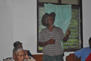
There were only few issues raised during the open forum because the Banao tribe has already understood the concept and decided to consider the whole ancestral domain of Banao as ICCA. An elder, Ama Mayongdad, called everybody’s attention to the fact that Balbalasang is also called by the national government ‘Balbalasang National Park or BBNP’. He suggested changing the BBNP into ‘Banao Lapat System Conservation’. Another suggested that the Banao community register the whole municipality of Balbalan as an ICCA and that not only the current three Banao barangays of Balbalasang, Pantikian and Talalang be called ICCAs (Balbalan municipality has 14 barangays). In addition, one elder suggested that all mountains, watersheds, rivers, creeks and sacred grounds be named under the Banao traditional names and put into the 3D map.
For its part, Mr. Reyes (KASAPI) presented procedures in starting ICCA work: formation of planning teams, participatory data gathering, community mapping, cross-sites visits, conducting of Resource Inventory (RI), community validation of research results and conservation planning. ICCA work can thus successfully begin only through participatory process. It starts with the formation of a local conservation planning team identified, nominated and appointed by elders through traditional decision-making process. The team in turn will organize workshop and orientation on procedures, put on schedule actual training and conduct of RI including the conduct of community validation of the results of the RI. It was also mentioned that the composition and number of members of the team should be discussed among the leaders so that the members shall be permanently designated for technology transfer and future monitoring. It was agreed that the local planning team will consist of 2 members from each barangays and 4 from the local NGO partner Concerned Citizens of Abra for Good Governance (CCAGG) for a total of 10 members.
It was also noted that the community agreed to treat the overlap areas or conflict areas as “gray areas” not to be touched until resolution.
It was interesting to note that the Lapat recognizes mining in the area; but mining as traditionally practiced by the local community members. An elder claimed that one mining area is becoming a nuisance because it has affected water quality in one of the streams. The group suggested that they should review the rules on mining in their Lapat and provide safety nets and penalties in cases of mine tailings and river poisoning.
Amongst the recommendations, it was decided that additional personnel will be hired from the community to augment the current staff of CCAGG; because with its current effectives, it will be strenuous and exhausting work considering the distance to travel from office to the community. KASAPI proposed a revised budget to include one motorcycle and two hand-held radio communications equipment and one base radio.
The activity ended with a sumptuous dinner with community representatives. The rains did not deter lively Focus Group Discussions towards midnight. By 10 am the next day, the team was off to Bangued, arriving there at 2 pm and off to a 13-hour drive to Manila.