Indonesia has recently published updated information about the status of recognition of Indigenous territories and customary forests

First published on 08/27/2021, and last updated on 10/03/2021
Shared by Kasmita Widodo, Coordinator, Working Group for ICCAs in Indonesia (ICCA Consortium Member)
In celebration of Indonesia’s 76th Independence Day, the Indigenous Territory Registration Body (Badan Registrasi Wilayah Adat, BRWA) issued updated information on the “Status of Recognition of Indigenous Territories in Indonesia” sourced from the BRWA Indigenous Territories Registration System. This system records data and information regarding the existence of Indigenous Peoples and their customary territories. Furthermore, BRWA carries out standardization of spatial data (maps) and social data (profiles) of Indigenous Peoples through the process of Registration, Verification, and Certification of Indigenous territories.
So far, BRWA has registered 1,034 maps of Indigenous territories covering an area of approximately 12.4 million hectares. The mapped territories are spread over 29 provinces and 136 districts/municipalities. The status of recognition of Indigenous territories is based on regional regulations. There are two types of local regulations: regulations can either directly establish the Indigenous territory (stipulation) or set the procedure for recognition (regulation) – in which case a Regent decree is usually required to complete the recognition process.
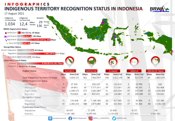 Complete information on the national and regional status of recognition of Indigenous territories and customary forests can be seen in this infographic. Photo: Badan Registrasi Wilayah Adat (BRWA)
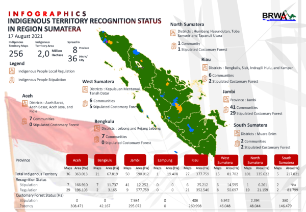 Complete information on the national and regional status of recognition of Indigenous territories and customary forests can be seen in this infographic. Photo: Badan Registrasi Wilayah Adat (BRWA)
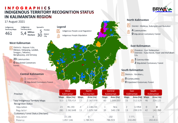 Complete information on the national and regional status of recognition of Indigenous territories and customary forests can be seen in this infographic. Photo: Badan Registrasi Wilayah Adat (BRWA)
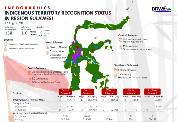 Complete information on the national and regional status of recognition of Indigenous territories and customary forests can be seen in this infographic. Photo: Badan Registrasi Wilayah Adat (BRWA)
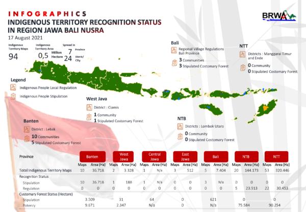 Complete information on the national and regional status of recognition of Indigenous territories and customary forests can be seen in this infographic. Photo: Badan Registrasi Wilayah Adat (BRWA)
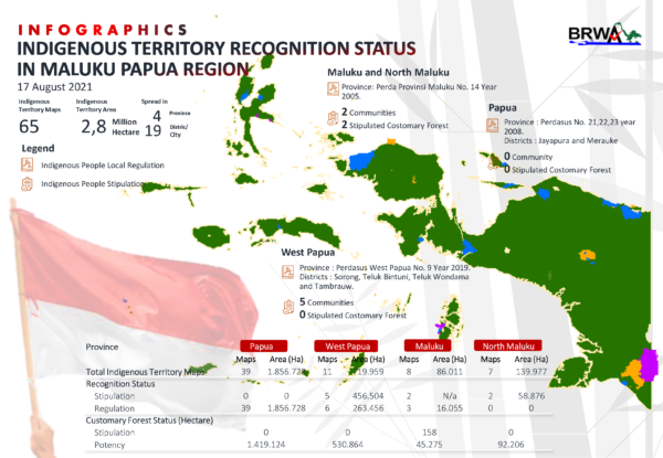 Complete information on the national and regional status of recognition of Indigenous territories and customary forests can be seen in this infographic. Photo: Badan Registrasi Wilayah Adat (BRWA)
So far, 154 Indigenous Territories have been recognized by the local government with an area of 2.46 million hectares, covering about 19.8% of the total customary areas registered in BRWA. In the provinces and districts/municipalities that have issued Regional Regulations setting the process for recognizing Indigenous Peoples, there is a potential of 617 maps of Indigenous Territories with an area of 7.66 million hectares to be processed for recognition. Meanwhile, around 2.31 million hectares of customary areas still do not yet have a legal umbrella for recognition.
From 12.4 million hectares of Indigenous Territory maps registered at BRWA, the potential for customary forests recognition reaches around 8.35 million hectares (as territory includes forest and non-forest area). Meanwhile, the Ministry of Environment and Forestry (KLHK) has issued 75 decrees recognizing Customary Forests with an area of 56,903 hectares or about 0.68% of the current potential of Indigenous Forests.
Complete information on the national and regional status of recognition of Indigenous territories and customary forests can be seen in this infographic (PDF file).