“Community mapping is the most effective method that can facilitate the identification of the ICCA and the conduct of local resource assessment and inventories.”
First published on 04/20/2023, and last updated on 11/13/2023
Written by Dave de Vera
Executive Director of the Philippines Association for Intercultural Development (PAFID, ICCA Consortium Member) and member of the ICCA Consortium’s Council of Elders
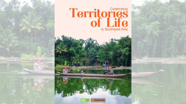
Note: This article is from the recently published report “Celebrating territories of life in Southeast Asia.” The text has been edited for the ICCA Consortium website.
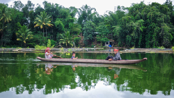
The Southeast Asia region occupies the expanse between China, India, Australia, and the Pacific Ocean.[1] It consists of eleven countries and is subdivided into Mainland and Insular zones. Mainland Southeast Asia is composed of the countries of Cambodia, Laos, Myanmar (Burma), Thailand, Vietnam, and Singapore. Insular Southeast Asia consists of Indonesia, the Philippines, Brunei, and East Timor archipelagic nations. Malaysia is unique as it is part of both zones.[2] Southeast Asia covers approximately 4.5 million square kilometers, about 10.5% of Asia’s total land area, and 13 million square kilometers, including the sea area.[3]
The whole region is in the tropical and subtropical climatic zones subject to the monsoonal weather system, which produces marked wet and dry periods and provides ample annual rainfall. Southeast Asia has three interconnected geophysical features: mountain ranges, plains and plateaus, and water in deep trenches, shallow seas, and extensive riverine or drainage systems.[4]
According to the World Atlas, the region’s population was about 655.2 million as of 2018, which accounts for 9% of the world’s total population. The population includes a wide variety of more than 100 ethnic groups with highly complex language patterns. Of the 6,000 languages spoken in the world today, an estimated thousand are found in Southeast Asia. This diversity results from the region’s position as a sea route, a barrier, and a bridge to people’s movements.
Southeast Asia: biodiversity and ICCAs–territories of life
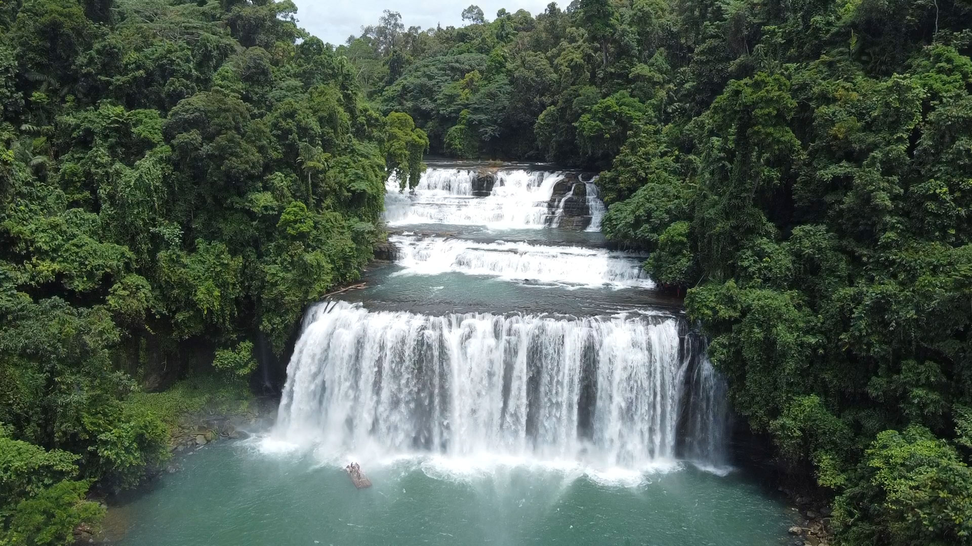
Southeast Asia is undeniably one of the most diverse regions in the world. Representing one of the world’s three major biodiversity and tropical landscapes, Southeast Asia hosts three of the twelve mega-diverse nations (Indonesia, Malaysia, and the Philippines). These areas contain an astounding 20% of the planet’s vertebrate and plant species with high rates of endemism. Southeast Asia is also home to nearly 15% of the world’s tropical forests.[5] The region’s wealth in terrestrial habitats and species is matched by its marine resources: it contains nearly 100,000 square kilometers of coral reefs, almost 34% of the world’s total, hosting the highest marine biodiversity in the world. It is also the global center of biodiversity for coral reef fish, mollusks, and crustaceans. As of 2004, the region contains 51 of the world’s 70 mangrove species and 23 of the 50 seagrass species.[6]
While it is globally recognized for its high biological diversity, Southeast Asia also has six of the 25 biodiversity hotspots in the world. Estimates suggest that habitat loss in the region is among the highest and most severe in biodiversity loss.[7] It has the highest relative rate of deforestation in the world, with estimates of around an average rate of 1% forest cover loss annually.[8] Southeast Asia could lose three-quarters of its original forests by 2100 and up to 42% of its biodiversity if this continues.[9] Marine biodiversity faces the same threat, with an estimated 88% of Southeast Asia’s coral reefs at risk. For 50% of these reefs, the threat level is “high” or “very high,” with only about 12% classified as low risk.[10] The heavy reliance on forest and marine resources for economic gain and to sustain ballooning populations has resulted in overexploitation and degradation.[11] Amidst this biotic threat, Indigenous and local communities in the region have been at the front line of preserving and protecting the remaining terrestrial and marine life habitats by sustaining their ICCAs.
Despite the absence of state recognition, traditional governance of ICCAs provides the sorely needed in-situ governance of rich and fragile environments. In the Philippines, almost 90% of the country’s Key Biodiversity Areas (KBAs) are located within traditional lands and territories of Indigenous communities. In Indonesia, around 70% of state-claimed forested areas are located in Indigenous Peoples’ territories used by the communities in shifting agriculture, hunting, and food gathering.
Range, diversity, and extent of ICCAs in Southeast Asia
Southeast Asia ICCAs are as diverse as the region’s cultural, ecological, and biophysical landscape. These are found in terrestrial and marine ecosystems – from the mountain ridges, dense forests, lowland plains, coastal areas, and coral reefs – providing habitats to a high diversity of flora and fauna and life and spiritual sustenance to the steward communities.
In terms of size, ICCAs in Southeast Asia could be as small as less than a hectare of forest patch used as a burial ground of revered tribal leaders on the island of Mindoro, Philippines, to 500,000 hectares of the Prey Lang Wildlife Sanctuary in Cambodia.[12]
Depending on how communities define their ICCAs, it could be just a part of the Indigenous territory, such as the Borong Karamaka (sacred forests) of Indonesia’s Ammatoa Kajang. ICCAs could also encompass the whole territory, such as the Pangasananan of the Manobo in the Philippines. However, The extent of ICCAs in Southeast Asia is yet to be determined. The United Nations Environment Programme – World Conservation Monitoring Centre’s (UNEP-WCMC) ICCA Registry cannot be a basis for the number and area because different countries have their processes and limitations in mapping and documenting ICCAs.
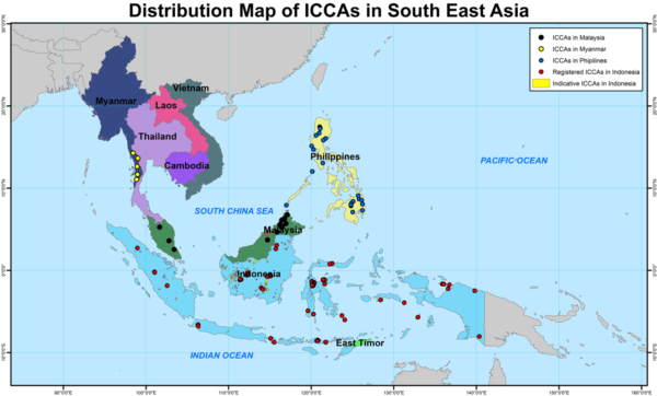
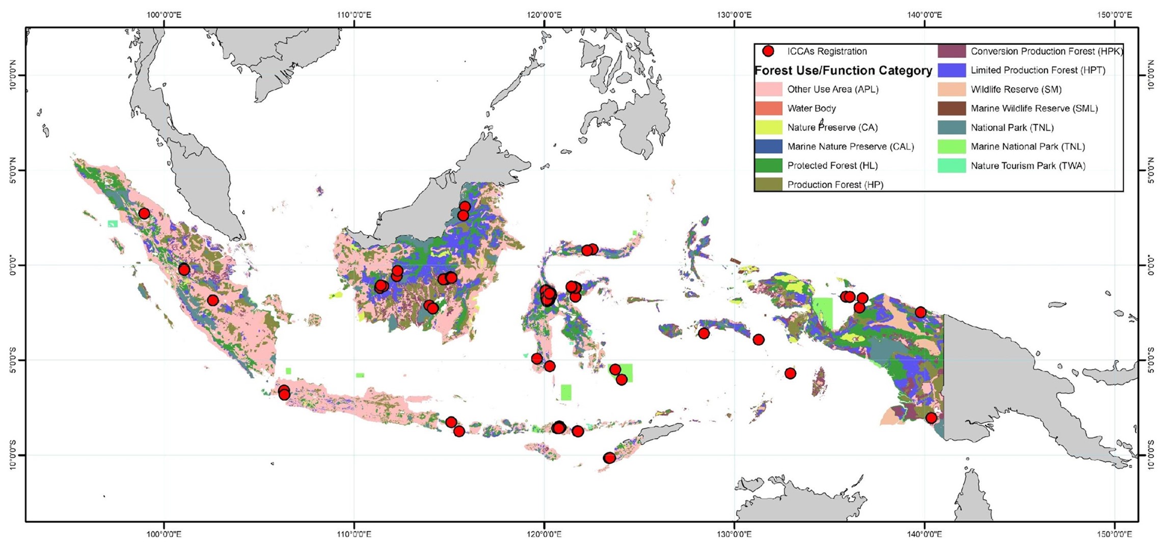
For example, in Cambodia, only one ICCA is registered, the Prey Lang Wildlife Sanctuary, when several Indigenous Peoples consider their community forests as ICCAs. Only Salween Peace Park is registered in Myanmar, but the ICCA NEWS recognizes over 20 ICCAs in the country. Malaysia has none, but the concerted efforts of organizations that are members of My ICCA have already documented 19 ICCAs. The Philippines and Indonesia have national registries at different stages in the process. The Philippines has mapped and documented at least 20 ICCAs, while Indonesia has mapped and registered 104 ICCAs with a total area of 462,650 hectares. Jaringan Kerja Pemetaan Partisipatif (JKPP), the organization that maps Indigenous territories and areas, estimates that the country has potentially over 2.9 million hectares of ICCAs.
Community motivations for conservation
Custodian communities have different reasons for sustaining the ICCAs in their territories. Still, often it is based on an innate and give-and-take relationship that they maintain with their environment. Motivations usually range from spiritual connectedness with the area, cultural significance of the place, and a source of food and livelihood security for the community. This is aptly described in a review of ICCA recognition and support in the Philippines by Pedragosa in 2012:
“ICCAs play an important role not only in the economic aspect of their life but also in developing their culture and socio-political systems. Religious and traditional beliefs, practices, and rituals have evolved out of their relationship with them. Many Indigenous Peoples and local communities regard conservation’s biological, economic, and social objectives as intimately related. Hence, their traditional activities include conserving a variety of natural environments and species for various purposes, economic as well as cultural, spiritual and aesthetic.”
This is true not only in the Philippines but also in other countries in the region. This is seen in the sasi system for lompa fish being implemented by the people of Haruku in Central Maluku, Indonesia, where the ICCA ensures continuous populations of lompa fish, an important source of food and livelihood for the community.[13] The Batak community of Palawan, Philippines, believe that their whole territory is endowed with sacredness, hence resources must be well managed.[14] The Penan of Malaysia establish rights to the resources within the territory which they occupy not by cutting down the forest but by ensuring that their relationship with the landscape is nurtured. One of their practices for this is to maintain resting places they call lasan along man-made jungle tracks, thereby creating a sense of ‘kinship’ with the environment while taking a break in the forest.[15]
Biodiversity conservation and climate change mitigation is not a motivation that many of the custodian communities had when their ICCAs were established but these are undoubtedly results of their age-old relationship with the resources in their environment.
Management and Governance
Custodian communities, especially Indigenous ones, have developed and practiced systems of governance and management that protects and sustains not only the physical aspects of the ICCA but also the relational aspect among the people in the community. The centuries of adaptation, practice, and experience contributed to the accumulated wealth of knowledge that is embedded in their cultures and day-to-day living. Governance and management of ICCAs vary among the different Indigenous and local communities in the region. These variations are usually determined by the spiritual beliefs, customs, and community institutions enforcing them, as well as the level of assimilation into the larger society. Common characteristics observed include: (1) management and governance structures and policies are derived from centuries-long experiences and adaptation practices, (2) resources are collectively managed and governed under local authority that promotes communal values, (3) management is based on self-determination, utilitarian, and very practical in nature; and (4) decision-making is based on current locally relevant issues and the existing body of traditional knowledge.[16]
These characteristics may have played a role in the conservation of natural resources, species and ecosystems in the region and, more importantly, helped sustain the custodian communities for centuries. This is evident in the practice of sasi, for example, which protects certain plants or animals from overexploitation by limiting harvest to certain times of the year. This allows time for regeneration, thereby ensuring that the resource in sasi will still be available for the community for a long time. A customary institution called the kewang has responsibility for implementing sasi rules and other customary resource management policies.[17] In some communities, spiritual authorities play a role in resource governance as shown by the Talaandig community in Portulin, Philippines, where a bailan (shaman) works with the customary head of the clan called the datu (chieftain). The datu, in turn, enforces the rules with assistance from local forest guards called the bantay lasang.[18]
One key feature in the governance and management of ICCAs is that it is rooted in the concept that Indigenous Peoples and other local communities are the custodians and caretakers, not necessarily owners, of these areas. It is not just about following orders and being scared by punishments but also about staying true to their cultural identity, being guided by their spiritual beliefs and social norms, and respecting the deep connection they have with their environment. This is why they “look at governance and management of ICCAs as part of their daily life and essential to their own well-being and survival”.[19] The community and their immediate environment are inextricably linked, and communities often say that the destruction of one leads to the eventual obliteration of the other, with emphasis on the dependence of the community to nature. This was aptly depicted in the words of a respected Indigenous leader in the Philippines, Hawudon Tinuy-an: “If we abandon the territory…we will perish and become nothing.”[20] This attaches a whole new meaning to “management and governance” for many of these communities and this also makes it more effective as compared to externally imposed management and governance mechanisms like government-established Protected Areas.
Although there are community institutions or structures tasked with enforcing rules, the duty and responsibility of ensuring that the ICCA is protected is shared among the members of the community. An example of this is the Igmale’ng’en sacred forests of the Talaandig community in the Philippines where community members, regardless of their status, inform the community chief of the status and observed violations against their Igmale’ng’en. Another example is how, traditionally, Indigenous Peoples in Cambodia regard natural resources as communal property used for subsistence lifestyles and not for the quest for individual profit. Hence, some rules are followed when extracting natural resources from the environment to limit overexploitation and to prevent individuals from taking away more than they should. In case mismanagement and overexploitation do happen, there is an organized system composed of elders which could handle conflict crisis and decide what to do at the village level with the aim of resolving the situation.[21]
As mentioned, mechanisms for ICCA management and governance in Southeast Asia is also shaped by the community’s level of exposure to and relationship with cultures and governing structures external to the community. Isolated communities solely follow their centuries old management rules and governing policies but for communities that have been assimilated into the larger society, their management and governing structures are often influenced by and sometimes overlaid with prevailing non-traditional structures. For example, the Prey Lang Wildlife Sanctuary is managed by both the Prey Lang Community Network (PLCN) and Cambodia’s Ministry of Environment. The Menuvu, Higaonon, and Talaandig communities living in and around the Mt. Kalatungan Natural Park in the Philippines work with the local governments and Protected Area Management Board to ensure that development and protection plans for the Protected Area are inclusive of their own plans and customary governance. This relationship also boosts protection and conservation efforts for the ICCAs as well as provides the necessary support for their livelihood needs. There are also ICCAs with management mechanisms modified to specifically reject meddling of external institutions such as in the Karen people’s Kawthoolei, or customary territory in Myanmar. Here, the Salween Peace Park was established to protect against the Myanmar government’s development and resource utilization plans that entails environmental destruction and disempowerment of local Karen communities.
ICCA Mapping Initiatives
To protect and conserve their Territories of life, Indigenous communities in Southeast Asia have initiated mapping and documentation activities. The need to document their ICCAs was identified by Indigenous communities in the Philippines as a priority activity that needs to be immediately addressed. In their Manila Declaration of 2012, they urged governments, non-government organizations (NGO) and the academe to provide support in building local capacities to effectively participate in activities that are critical to the recognition and protection of their traditional conservation areas. The same level of urgency and importance is apparent from other countries where communities and NGOs have invested heavily in the mapping of Indigenous territories.
There are a multitude of methods and tools available that can be used to effectively document ICCAs. However, a participatory approach in conducting research allows for a more in-depth analysis of the information based on the local and traditional knowledge. It also provides the opportunity for shared learning and validation that accords a strong sense of local ownership of the data and information amongst the members of the community, and ensures the quality, relevance, usefulness and validity of the research. Community mapping is the most effective method that can facilitate the identification of the ICCA and the conduct of local resource assessment and inventories.
Community Mapping Processes Used by Indigenous Communities in Southeast Asia to Document their ICCAs
Sketch mapping – Community members draw maps on the ground or on paper based on their collective memories. The maps represent salient features of the land and other natural resources from a community’s perspective. The community members do not rely on exact measurements and do not use a consistent scale or geo-referencing. They do show the relational size and position of features.
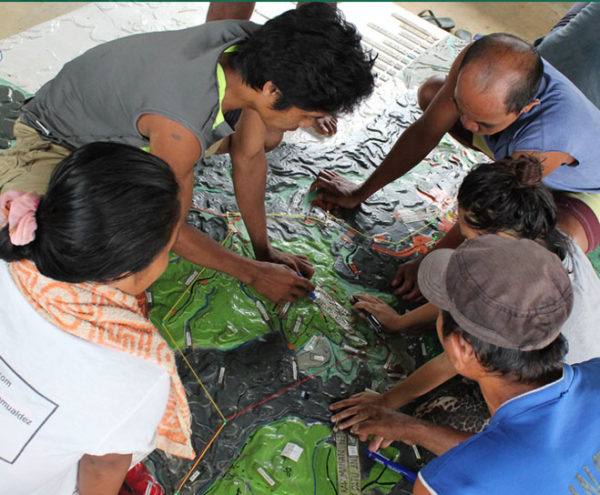
Participatory 3D Models (P3DM) – Created from the template of a topographic map where pieces of cardboard or rubber sheets are cut in the shape of the contour lines and pasted on top of each other. The model is then finished with wire nails, glue, plaster, and paint. Geographic features are depicted on the model using push pins (for points), colored string (for lines) and paint (for areas). A scaled and geo-referenced grid can be placed in the model to facilitate proper digitalization.
Eco-cultural Mapping – Collects Indigenous Peoples’ perception concerning forest areas, grasslands, cultivated areas, water sources, sacred places, and natural resources within their domain. The community members are gathered and consulted about their agricultural practices, cultural norms, and traditional beliefs. The eco-cultural maps are drawn showing the community and geographic boundaries, roads, water sources, cropland, pastureland, forested areas, major community infrastructure and others.
Participatory Geographic Information Systems (PGIS) – Combines a range of geospatial information management tools and methods such as sketch maps, P3DM, aerial photographs, satellite imagery, Global Positioning System (GPS), and GIS to represent peoples’ spatial knowledge as virtual or physical or two- or three-dimensional maps. These are used as interactive vehicles for spatial learning, discussion, information exchange, analysis, decision making, and advocacy. This makes global information technology (GIT) available to disadvantaged groups to enhance their capacity to generate, manage, analyze, and communicate spatial information.
Mapping the Pangasananan of the Manobo Communities
Philippines
The Pangasananan is the 6,996-hectare territory of the Manobo people situated in Bislig City, Surigao del Sur. The name comes from pangasan, the act of obtaining food and other needs such as timber, ritual materials, decoration and household materials, and anan as suffix denoting a place. For the Manobo people, the Pangasananan is everything they need – providing them food, shelter, medicines, water and identity. Its destruction is also their downfall. Hence, it is of prime importance for them to protect, conserve and manage it to ensure their survival.
The Pangasananan ICCA is part of the South Diwata/Bislig Key Biodiversity Area (KBA) and the Bislig Important Bird Area (IBA), which features endemic lowland dipterocarp forests with 21 vertebrates and 9 plants that are globally threatened. According to BirdLife International, the Bislig IBA hosts threatened and restricted-range bird species namely Mindanao brown-dove, Mindanao bleeding-heart pigeon, spotted imperial-pigeon, silvery kingfisher, rufous-lored kingfisher, wattled broadbill, azure-breasted pitta, Philippine leafbird, little slaty flycatcher and celestial monarch. The Pangasananan forest is also a breeding ground for the Critically Endangered Philippine Eagle and the entire area is part of its feeding ground.
Until the mid-1950s, the Pangasananan was almost entirely forested. But logging companies, most notably Paper Industries Corporation of the Philippines, Inc. (PICOP), operated for more than 50 years through government issued permits. Aside from clearing the forest, the company also planted foreign tree species for pulp production. Towards the end of its contract, the company inched closer and closer to the remaining forest, which inevitably brought the Manobo face to face with threats to lives and livelihoods – houses were burned, farms destroyed, tools confiscated, and Manobo people criminalized. Commercial logging stopped in 2008, but logging roads opened by the company allowed migrants easy access to the forests, who cleared more forest and took residence in the Manobo territory without consent. In 2018, a new threat emerged when 45% of their territory was declared a Protected Area without their consent – the Tinuy-an Falls Protected Landscape.
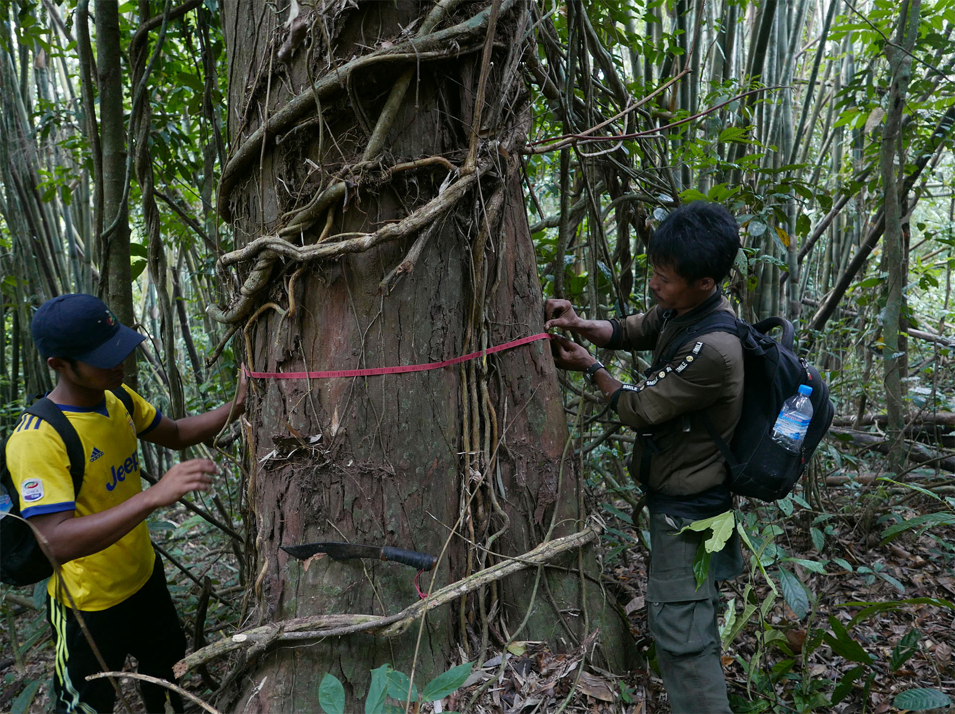
The Manobo of Sote decided to map their Pangasananan using P3DM in order to create a record of their territory which they can use to engage other stakeholders as well as a planning tool that can be used by the community during its regular assemblies. With the assistance of Philippine Association for Intercultural Development (PAFID), the mapping process started with a series of consultations during which key group members, such as elders and leaders, provided information about their territory and discussed their needs and obligations with regard to the land. The members then produced rough sketch maps of their domain, and identified its boundaries and important geographical features such as mountains and water bodies. The dimensions and coordinates of these features are verified by GPS ground surveys, and the sketch maps are refined.
Next, the group created a “blank” relief model, which starts out as a series of layers of cardboard. Single contour lines from topographic maps were traced onto the cardboard, and the pieces cut out and pasted one on top of the other to build up a 3D model of the area. The members of the group brought the relief model to life using paint, yarn and push pins of various colors and sizes to indicate the details identified on the sketch maps, as well as natural resources, land cover, settlements and infrastructure. Other features, including administrative boundaries or protected areas, can be added to the model at a later stage. The meanings of the various map elements remain clear and consistent because all community members refer to a single, mutually agreed upon legend.
The next step in the process involved taking high-resolution digital photographs of the 3D model that can be integrated into a geographical information system (GIS) so that the data are more widely accessible. Once the images have been stored in a computer, they may be corrected with additional GPS ground survey data and combined to produce 2D thematic maps such as of land cover or natural resources. These maps are validated by the community to ensure accuracy and local adoption. The 3D models and the 2D GIS maps are regularly updated to reflect any changes in land use.
With their 3D map, the community was able to define the traditional governance boundaries of their territory. They divided the territory into nine sectors to better manage it. The sectors are named after major water bodies in each area namely Danao, Tinuy-an, Tabonan, Anislag, Mag-usa, Baguis, Daganluson, Sungkuan, and Sayaw. Each sector is headed by a hawudon. This map of the governance boundaries clarified the responsibilities and jurisdictions of each clan. This has resulted in a stronger relationship among the various clans in the territory as well as the more efficient implementation of their forest management policies.
The P3DM also helped them prove their occupation of the land since time immemorial. This has been very useful in the approval of their Certificate of Ancestral Domain Title (CADT). Now that the tribe has legal title to the land, the provocations and the violence have ceased. The P3DM models are also proving invaluable in natural resource planning. With increasing pressure on diminishing resources such as freshwater, forests and fish, making sustainable development plans is crucial to the survival of small tribes. Because the physical 3D features of this model are immediately recognizable, all members – including elders and those who cannot read – are able to participate in resource planning. Such models have been used in resolving inter-tribal conflicts over resources, most notably water, and in pointing out problem areas and solutions to government planners.
The Manobo of Sote and PAFID’s experiences demonstrate that an intelligent combination of participatory decision-making and modern technology can provide solutions to land conflicts and assist in natural resource planning. The secret of the success of the P3DM approach lies in its ability to engage both Indigenous community members and the authorities in an ongoing political dialogue that is mutually beneficial.
Initiatives of the Karen to Map and Conserve their Territory of Life*
Myanmar
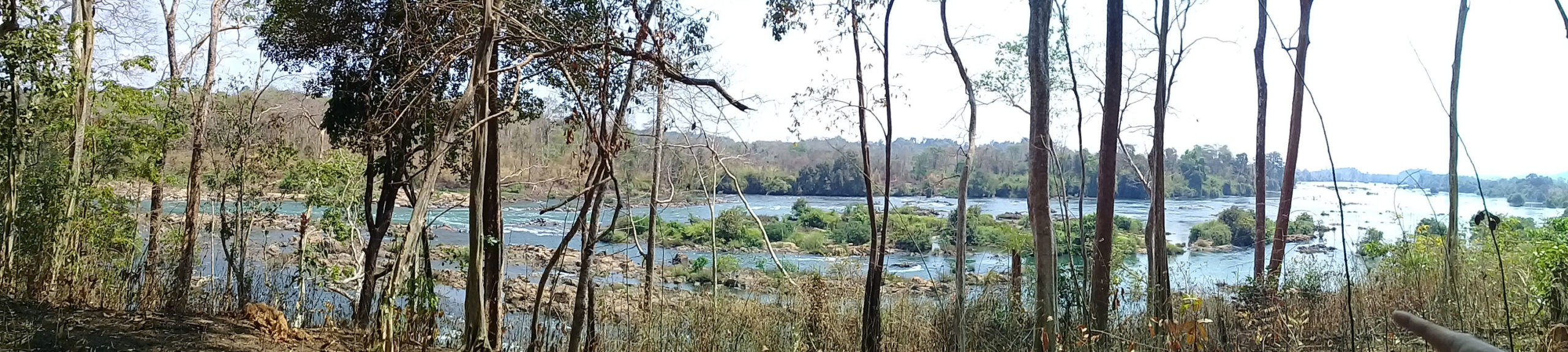
The Salween River basin contains one of the last great wild landscapes and natural teak forests of Southeast Asia. It supports some of the most biodiverse areas in the world and is home to threatened wildlife such as tigers, Asian elephants, banteng and the Critically Endangered Sunda pangolin. Roughly 2,400 kilometers long, the Salween flows from the Tibetan Plateau through Yunnan into Myanmar, briefly touching Thailand. It is one of the few major rivers in Asia that still flows freely and uninterrupted by large-scale dams. It is also home to diverse Indigenous groups including the Akha, Blang, Derung, Hmong, Kachin, Karen, Karenni, Kokang, Lahu, Lisu, Mon, Nu, Palaung (T’arng), Pa’O, Shan, Tibetan, Yao, and Wa. These communities are key to the conservation of Salween and its resources.
As custodians of the Salween River, community members maintain a spiritual relationship with the Salween, as their ancestors have done since they descended from the Tibetan Plateau many centuries ago. For the Karen, Salween is home to countless important spirits who are intermediaries between human societies and the environment around them. It supports the sacred animal and plant species who populate the cosmos and carries the memories of their ancestors whose lives were intertwined with the river. Their relationship with the spirits is maintained and the memories of their ancestors kept alive by their continuous interaction with the Salween River, the backbone of their traditional knowledge and practices.
After many years of conflict, the Karen wanted to protect their territory from extractive industries and established the Salween Peace Park. The heart of this initiative is the kaw, the Indigenous Karen system which is a physical area and social institution for sustainable land governance. Kaw integrates Indigenous ecological knowledge, protected areas, rotational upland fields, taboos against hunting keystone species and peaceful conflict resolution mechanisms.
The partnership between Mutraw District communities, the Karen Environmental and Social Action Network (KESAN) and the Karen National Union (KNU) has resulted into the establishment of the Salween Peace Park and its map. With support from KNU forest rangers and funding from the Rainforest Trust in Norway, the communities mapped the park, delineated community ownership, and documented its biodiversity. With a total area of 548,583 hectares, it is comprised mostly of 248 kaw at 415,301 hectares. It also contains 34 community forests and three wildlife sanctuaries. Mutraw communities have also been mapping their traditional socio-ecological management practices, highlighting the invaluable Indigenous and natural diversity that they encompass. The park serves as a sustainable alternative to megaprojects, as well as a way for refugees and displaced people to reintegrate into Karen State with minimal disruption of the natural environment.
The Salween Peace Park initiative builds on more than a decade of community-based conservation work. The survival of this landscape and its biodiversity thus far can be explained by the indigenous Karen environmental ethic that integrates sustainable livelihoods, nature protection and democratic governance. This cultural heritage is an invaluable asset to a world facing species extinction and climate change.
The Significance of Land for the Malind People*
Indonesia
by Prasetyo and (late) Agustinus Kanki Balagaize, Malind Anim customary chief
The Malind Anim Indigenous Peoples in southern Papua have a deep bonding with the land on which they live. This relationship derives from a recognition that it is the land that sustains and protects them. They are born in the forest and are almost completely dependent on forest resources to meet all their livelihood needs, including medicines.
The Malind Anim’s relationship with their land is reinforced by frequent trips and extended stays in the forest, and is reflected in an extensive body of knowledge and local wisdom. For example, members of the community assess the fertility of the soil by observing the trunk shape or leaf color of the vegetation growing in a particular area. They also know when to plant or harvest forest resources based on the observation of the winds and fruit season of particular plants.
Over time, the Malind Anim people have developed customary rules to protect their natural resources. Examples are the prohibition on catching birds of paradise or other birds except for ritual purposes; no hunting of species that are the symbol or totem animals or plants of particular clans is allowed; use of fire is also strictly monitored and managed because of the big threat it represents to the habitat; immature sago plants that are not yet productive may not be harvested or damaged. All members of the community are expected to adhere to these laws and there are sanctions that are imposed when there are violations.
For the Malind people, their relationship with the land is of the utmost significance and they are fiercely protective of their traditional lands. The boundaries of the customary land are marked with totems including drawings or carvings of rattan, coconut tree, birds of paradise, cassowary and other animals or plants. Their social structure is regulated by clanship and belief systems associated with particular plants and animals. The Gebze clan of the Malind Anim peoples, for example, is connected to the land, stones, and all animals that live in symbiosis with the coconut tree.
When community mapping was introduced to the Malind community, it became the natural way for them to visualize the close relationship with the customary land, its boundaries, and enable them to secure the community’s sources of livelihood and to preserve its cultural identity. Sites regarded as particularly sacred include ancient graves, which are marked by large rocks or trees. It is believed that the spirits of the dead remain in a single location and protect it. When a child is born, that child will continue to have strong ties with the village of birth throughout his life, because it is believed that the child’s birth has been witnessed by the ancestors’ spirits. Thus, the Malind people continue to protect their customary villages to ensure that their ancestors’ spirits will protect them from danger and diseases.
If the land and the forest are life for the Malind Anim Indigenous Peoples, they also believe that the destruction of the natural environment will result in the death of all living beings. “If nature is destroyed, then all living things will die and perish. First, the small creatures will die and disappear, followed by the larger animals, and then finally human beings.”
* Abridged from an article with the same title in Prasetyo & Bagalaize. (2021). The significance of land for the Malind people. In Working Group on ICCAs in Indonesia, The long struggle of Indonesia’s Indigenous Peoples for conservation and living space: Fifteen stories of Indigenous Peoples’ and community conserved areas and territories (ICCAs) in Indonesia. Working Group on ICCAs in Indonesia.
* Abridged from KESAN. (n.d.) The Salween Peace Park: A vision for an Indigenous Karen landscape of human-nature harmony in southeast Myanmar. http://kesan.asia/wp-content/uploads/2017/12/Revises-Eng-Peace-Park-briefer_web.pdf; and from Twa, S.P.S., Fogerite, J. & Palmano, C. (2021). Hkolo Tamutaku K’rer: The Salween Peace Park in Burma/Myanmar. In ICCA Consortium, Territories of life: 2021 report (pp. 111-120). ICCA Consortium. report.territoriesoflife.org
[1] World regional geography: People, places, and globalization. (2012). University of Minnesota Libraries. Retrieved May 1, 2022 at https://open.lib.umn.edu/worldgeography
[2] Andaya, B.W. (n.d.) Introduction to Southeast Asia: History, geography, and livelihood. Asia Society. https://asiasociety.org/education/introduction-southeast-asia.
[3] Southeast Asia. (n.d.) World Atlas. Retrieved May 1, 2022 from https://www.worldatlas.com/geography/southeast-asia.html
[4] Leinbach, T.R. & Frederick, W.H. (2020, November 10). Southeast Asia. Encyclopedia Britannica. https://www.britannica.com/place/Southeast-Asia
[5] Coca, N. (2020, December 1). Southeast Asia’s Imperiled Biodiversity. The Diplomat. https://thediplomat.com/2020/12/southeast-asias-imperiled-biodiversity
[6] Burke, L., Selig, E., & Spalding, M. (2004). Reefs at risk in Southeast Asia. World Resources Institute, United Nations Environment Programme-World Conservation Monitoring Centre, the World Fish Center, and the International Coral Reef Action Network.
[7] Estoque, R.C., Ooba, M., Avitabile, V., Hijioka, Y., DasGupta, R., Togawa, T., & Murayama, Y. (2019). The future of Southeast Asia’s forests. Nature Communications 10, 1829. doi.org/10.1038/s41467-019-09646-4
[8] Miettinen, J., Shi, C., & Liew, S.C. (2011). Deforestation rates in insular Southeast Asia between 2000 and 2010. Global Change Biology 17, 2261– 2270.
[9] Sodhi, N.S., Koh, L.P., Brook, B.W., & Ng, P.K.L. (2004). Southeast Asian biodiversity: An impending disaster. Trends in Ecology & Evolution, 19(12), 654-660. DOI:10.1016/j.tree.2004.09.006
[10] Burke, L., Selig, E., & Spalding, M. (2004). Reefs at risk in Southeast Asia. World Resources Institute, United Nations Environment Programme-World Conservation Monitoring Centre, the World Fish Center, and the International Coral Reef Action Network.
[11] Nilsson, L. (2019). The biodiversity loss crisis in Southeast Asia: A literature review on current research. [Unpublished manuscript]. University of Malmo.
[12] Prey Lang Wildlife Sanctuary, Cambodia. (2020). ICCA Registry. https://www.iccaregistry.org/en/explore/Cambodia/prey-lang-wildlife-sanctuary
[13] Soselisa, H.L. (2019). Sasi lompa: A critical review of the contribution of local practices to sustainable marine resource management in Central Maluku, Indonesia. IOP Conference Series Earth and Environmental Science, 339(1), 012013. DOI:10.1088/1755-1315/339/1/012013
[14] Novellino, D. & Batak Community of Tanabag. (2008). Kabatakan: The ancestral territory of the Tanabag Batak on Palawan Island, Philippines. https://www.iccaconsortium.org/wp-content/uploads/2018/04/KABATAKAN-IT-TANABAG.pdf
[15] Jaringan Orang Asal SeMalaysia, Lasimbang, J., & Dukim, C.O. (2015). Indigenous Peoples in ASEAN: Malaysia. Asia Indigenous Peoples Pact.
[16] Pedragosa, S. (2012). Recognition and support of ICCAs in the Philippines. In A. Kothari, C. Corrigan, H. Jonas, A. Neumann, & H. Shrumm (Eds), Recognising and supporting territories and areas conserved by Indigenous Peoples and local communities: Global overview and national case studies (pp. 134-137). Secretariat of the Convention on Biological Diversity, ICCA Consortium, Kalpavriksh, and Natural Justice.
[17] Soselisa, H.L. (2019). Sasi lompa: A critical review of the contribution of local practices to sustainable marine resource management in Central Maluku, Indonesia. IOP Conference Series Earth and Environmental Science, 339(1), 012013. DOI:10.1088/1755-1315/339/1/012013
[18] De Vera, D. & Guina, J. (2008). Igmale’ng’en sacred forests of Portulin- part of the ancestral domain conserved by the Talaandig Peoples of Mindanao, Philippines. [Unpublished manuscript]. https://www.iccaconsortium.org/wp-content/uploads/2015/08/grassroot-philippines-portulin-2008-en.pdf
[19] Pedragosa, S. (2012). Recognition and support of ICCAs in the Philippines. In A. Kothari, C. Corrigan, H. Jonas, A. Neumann, & H. Shrumm (Eds), Recognising and supporting territories and areas conserved by Indigenous Peoples and local communities: Global overview and national case studies (pp. 134-137). Secretariat of the Convention on Biological Diversity, ICCA Consortium, Kalpavriksh, and Natural Justice.
[20] Tabanao, G. (2021). Pangasananan: The territory of life of the Manobo people in Mindanao, the Philippines. In ICCA Consortium, Territories of life: 2021 report. ICCA Consortium. report.territoriesoflife.org
[21] Bourdier, F. (2015). Indigenous Peoples in ASEAN: Cambodia. Asia Indigenous Peoples Pact.